• Skip to primary navigation
  • Skip to main content
  • Skip to footer
Eno River Association

Eno River Association

Protect. Advocate. Learn.

skink link to Eno Fest
  • Explore
    • Places
    • Activities
    • Events
  • Protect
    • Conservation
    • Stewardship
    • Advocacy
  • Learn
    • Education Programs
    • Plants and Animals
    • Culture and History
    • Diversity, Equity, Inclusion, and Access
    • Climate Change Statement
  • Festival
  • Get Involved
    • Donate
    • Volunteer
    • Join our Email List
  • Donate

Search Eno River Association

Panther Branch Natural Area

ERA-Owned Nature Preserves

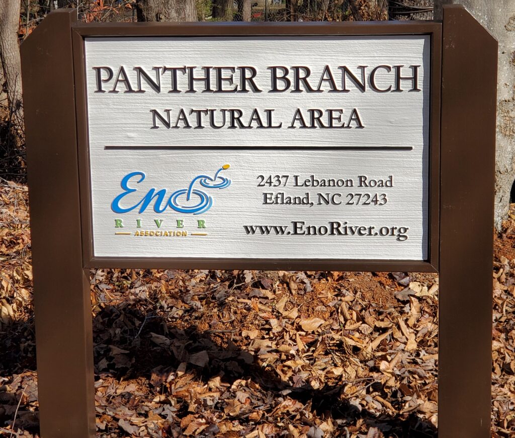
Address: 2437 Lebanon Road, Efland, NC 27243. Map it.

Hours: Dawn to Dusk, 7 days a week

Amenities and Attractions: 
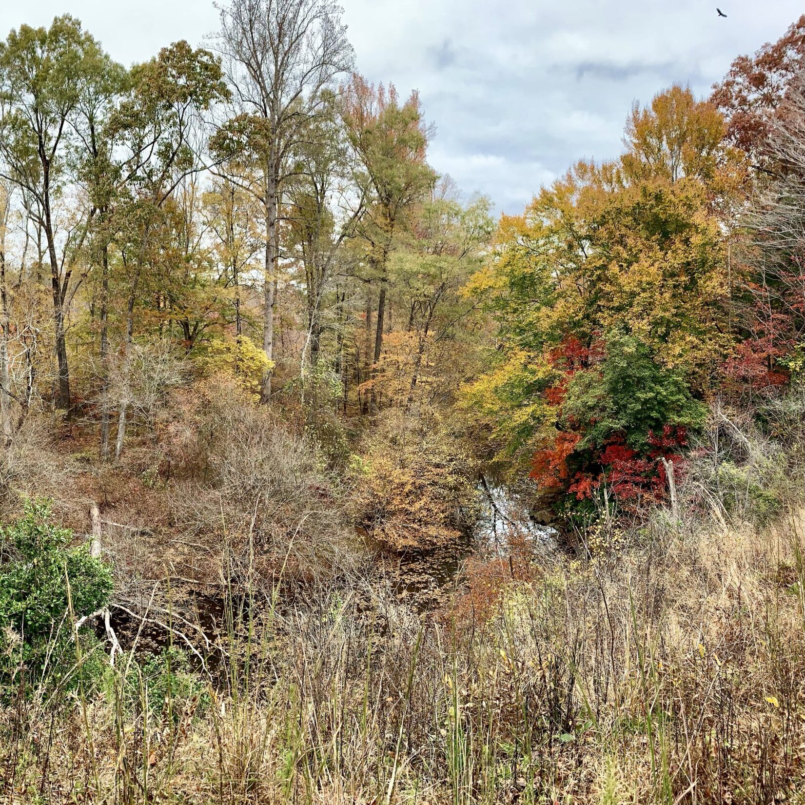
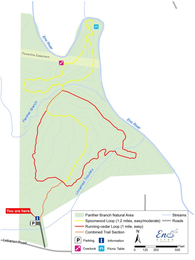
  • 2+ miles of walking trails thru 56 acres of mature hardwood forests
  • Picnic tables, Eno River vistas, and gravel parking area
  • Note: No restrooms on site
  • 3 miles from I-85 / I-40, easy to access from the Triangle and beyond
Trail Map

The Panther Branch Natural Area is owned and managed by the Eno River Association. It is a 56-acre preserve open for low-impact recreational uses, such as hiking along approximately 2 miles of trail, picnicking, and photography. It opened to the public in April 2023.

Support our Parks!

Panther Branch Natural Area was purchased and protected by the Association in 2017 with funding support from the NC Land & Water Fund, Orange County, City of Raleigh Watershed Protection Program, and other Eno donors.

Seed funding to prepare the site for public opening was provided by Dominion Energy, First Horizon Foundation, Mountain Dew, the Duke Doing Good – Community Fund, and general operating support from members like you.

You can ensure this site can welcome the anticipated 5,000 visitors in the first year alone with your additional donation today.

Give in support of Panther Branch

Frequently Asked Questions

What are the preserve rules?
  • Stay on Designated Trails
  • No Off-leash Dogs
  • No Bicycles, Motorized Vehicles, or Horses
  • Do Not Litter (pack it in, pack it out)
  • No Camping, Fires, or Hunting
  • Fishing permitted with a valid fishing license
  • No Disturbing or Collecting of Flora and Fauna or Extraction of Rock/Minerals or Water
  • No Weapons, Illegal Drug or Alcohol Use
  • No Entering or Damaging Structures
What is the accessibility of the site?
  • Parking: Gravel surface lot within 50 feet of trailhead
  • Trail difficulty: Easy to moderate natural surface, varying widths from 2-6 feet, varying grades including several steep inclines (Yellow Trail), the Yellow Trail requires traversing a 25 foot wide creek using boulders, hiking poles recommended
  • Language: Signage in English and Spanish
  • Other features: benches located in parking lot and on the east side of the Red Trail
  • Visit our Accessible Activities page for more ways to discover the Eno
What is the history of the preserve?

Indigenous Land Use

This is the traditional and ancestral homeland of the Eno, Shakori , Sissipahaw, Occaneechi, other people of Siouan descent, and their descendants, the Occaneechi Band of the Saponi Nation. The Eno River Valley was their home for thousands of years before the arrival of people from other continents. Indigenous people are the original stewards of this land.

Colonial Land Use

While we don’t know much about the early history of this property, we can presume that it was in farm use. The only known historical feature for this property is Lebanon Road, which was the colonial road known as the “Great Road” that led from Hillsborough to Faucett Mill, a former grist mill that was built before 1792, and then continued west to Guilford County.

How did the Eno River Association come to own this property?

Panther Branch Natural Area was originally two separate, adjacent properties owned by members of the Iski Family. When they placed the property on the market, a realtor connected them with the Eno River Association. The landowners had a desire to see their properties preserved and eventually opened to the public. The realtor knew about our work through the Festival for the Eno where she volunteered for several years.

The property was acquired in 2017 with financial support from the County, State, and City of Raleigh. In 2022, thanks to the support of additional funders, a parking lot, trails, and other amenities were installed. The facility opened to the public in April 2023.

Why don’t the trails run right along the river?

While we also love riverside hiking, we have to acknowledge the ecological impact it has on water quality and river health. Riverside trails damage riparian buffers — forested or vegetated land along a body of water which stabilize the streambank. In addition to preventing soil from eroding into the water, riparian buffers act as a filter to remove pollutants.

Because preserving riparian buffers is critical to protecting our water resources and improving the climate resilience of our communities, the NC Land and Water Fund limits activities within 50 feet closest to the waterway for properties they help fund. Specifically, the 30 feet closest to a waterway must remain undisturbed, and the 20 feet outside of that can be managed vegetation. So, not only is it the best ecological decision to keep trails off the riverbanks, it is also required by our funding partner. Learn more about riparian buffer regulations.

The Neuse River, of which the Eno is a tributary, provides drinking water to more than a million North Carolinians downstream. Panther Branch features over a mile of river frontage, and we’re proud to support the water quality of the Eno River for all our friends downstream, by giving you the opportunity to enjoy it from afar. Thanks for staying off the banks!

Photo by Tom Davis

Feature photo of Panther Branch Overlook by Audrey Vaughn

Footer

Contact

Eno River Association
4404 Guess Rd.
Durham, NC 27712
(919) 620-9099

Become a Friend of the Eno

Join our Email List

Connect

  • Email
  • Facebook
  • Instagram
  • Twitter
  • YouTube

Key Links

  • About
  • News
  • Shop
  • Festival for the Eno
  • Board Login

Recent Posts on Instagram

Woodland forms of buffalo and elk once ranged the Woodland forms of buffalo and elk once ranged the mountains and the northwest piedmont in scattered herds. Yet even by the arrival of the early European explorers, their numbers were scarce. Both species were largely eliminated by hunting and indigenous tribes most likely traded these animals on the Great Indian Trading Path. While buffalo were occasionally seen between 1720 and 1750, they were gone by 1765. Elk may have died out even earlier, around 1700. Remnants of the buffalos statewide presence persists in many place names like Buffalo Creek in northern Orange County. Some say that even our earliest roads, deeply carved with curved banks, were buffalo trails. 

๐Ÿ“ธ: Betsy Russell
Text source: 1985 Calendar

[image description: river in winter sunlight with trees and banks dusted in snow]
In 1701, explorer John Lawson wrote that he encoun In 1701, explorer John Lawson wrote that he encountered men with "very long Arrows, headed with pieces of Glass, which they had broken from Bottles. They had shap'd them neatly, like the Head of a Dart; but which way they did it, I can't tell."

It is believed that these projectile points Lawson remarked on were not a slovenly make-shift from broken bottles, but were dexterously chipped from clear quartz, a difficult medium requiring skill. 

If you ever do find artifacts like these at the Eno parklands, record your find with a ranger, but make sure to leave the history undisturbed. 

๐Ÿ“ธ: Holly Reid 
Text source: 1979 Calendar

[image description: circular ripple on still water with reflection of trees]
This month's Year of the Trail highlight is Bobbit This month's Year of the Trail highlight is Bobbitt's Hole Trail! ๐ŸŒณ

Bobbitt's Hole Trail is known for its scenic beauty ๐Ÿž๏ธ and offers visitors a chance to explore a gorgeous section of the Eno River. It's an easy trail that is an approximate 1.65 mile loop. The trail takes hikers through a wooded area along the riverbank and leads to Bobbitt's Hole, a picturesque swimming hole in the Eno River. ๐ŸŠโ€โ™‚๏ธ The trail is accessed via the Cole Mill parking lot at the end of Old Cole Mill Road. ๐Ÿš—

We hope you visit soon and enjoy your adventure! ๐ŸŒ„ 

๐Ÿ“ธ: Fred Myers
[Image Description: A cluster of bright red berries grow on a stalk.]
The Christmas Fern, Polystichum acrostichoides, is The Christmas Fern, Polystichum acrostichoides, is one of the most commonly encountered ferns along the Eno ๐ŸŒฟ In the past, the green leaves were gathered by New England settlers during the Christmas season for greenery indoors. If you look closely, you may be able to see the shape of a Christmas tree in the general outline of the fronds, or perhaps within the shape of each individual leaf, the image of Santa's stocking ๐ŸŽ„๐Ÿงฆ An abundance of these ferns generally indicates a rich, well-drained soil situation where moisture is available for most of the year. 

๐Ÿ“ธ: Duncan Heron
Text source: Ken Moore, ENO Journal, Vol. 4, No. 1, 1976

[image description: green fronds poking out of the snow]
There were once two fording rocks at Cole Mill For There were once two fording rocks at Cole Mill Ford. Old timers used to say that if you could see both rocks, you could walk your horse across. If you were only able to see one, you would have to swim your horse. And if you couldn't see either of the rocks, you would be wise not to cross at all ๐Ÿชจ๐ŸŽ๐ŸŒŠ-- Harry Umstead, Durham 

๐Ÿ“ธ: Dave Cook
Text source: 1973 Calendar 

[image description: water rushes over rocks creating white splashes]
The clock for the Orange County Courthouse was giv The clock for the Orange County Courthouse was given to the town of Hillsborough by George III in 1766. Around the time of the revolutionary war, Cornwallis' troops came to Hillsborough. The people of the town threw the weights and the bell of the clock into the Eno because they were worried the British would melt them down to make bullets. The soldiers couldn't do anything with face of the clock, so that didn't make it into the river. The weights were recovered, but the bell was never found ๐Ÿ””-- Allen Lloyd, Custodian of the Clock, Hillsborough

๐Ÿ“ธ: Duncan Heron
Text source: 1972 Calendar

[image description: black and white photo of Orange County Courthouse, a brick building with white pillars and a clock tower]
Load More... Follow on Instagram

Copyright © 2023 ยท Eno River Association ยท All Rights Reserved

Website by Code the Dream & Tomatillo Design